Coastal Protection Plan
for City-East Coast


for City-East Coast

The City-East Coast holds some of Singapore's most cherished places - from the iconic Esplanade and St James Power Station to East Coast Park and Changi Beach Park. Since 2021, PUB has carefully studied the coastal protection solutions for this region, which can be split into three sections:
1. Greater Southern Waterfront
2. East Coast
3. Changi
| If we do nothing | With coastal protection measures in place |
|
|
| Map showing the areas in Singapore that would be flooded during extreme coastal event in 2050, if no action is taken | The goal of no high-impact coastal flooding with the coastal protection plan for Greater Southern Waterfront, East Coast, and Changi in place |
The Greater Southern Waterfront (GSW) stretches from Pasir Panjang Terminal to Marina East, featuring popular destinations like VivoCity, Marina Bay Cruise Centre Singapore, and Labrador Nature Reserve.
A major transformation awaits when the City Terminals move to Tuas in 2027, freeing up about 1,000 hectares of prime waterfront land. This presents an exciting opportunity to repurpose the spaces for live, work and play while integrating essential coastal protection measures.
Along the southern coast under the Greater Sentosa Masterplan, there are initiatives to create a seamless waterfront promenade with opportunities for the connectivity to be extended to Sentosa and Pulau Brani, envisioned to host world-class attractions, enhanced beach experiences, and expanded nature and heritage trails.
A tale of two choices: What stakeholders say about the options for GSW
Two coastal protection schemes have been considered for GSW. One is the centralised scheme, where coastal barriers are built at the eastern and western ends of Sentosa and Brani to protect the coastline behind them. The alternative is a decentralised scheme, which would require walls hugging the entire shoreline of GSW with multiple tidal gates and pumping stations at the respective drain outlets.
| Decentralised coastal protection scheme | Centralised coastal protection scheme |
|---|---|
| ✓ Provides greater flexibility for incremental build of coastal protection measures | ✓ Protects a larger area, including Pulau Brani and northern Sentosa |
| ✕ Blocks sea view | ✓ Offers connectivity opportunities between mainland and the islands |
| ✕ Requires more land space to accommodate multiple tidal gates | ✓ Maintains a seamless waterfront experience with less disruption to businesses, residents, and waterfront users |
| ✕ Potential impact on existing biodiversity (e.g. intertidal areas) | ✕ Potential impact on marine vessel movement and biodiversity |
Pros and cons of the coastal protection schemes discussed at Our Coastal Conversation

We recommend adopting the centralised scheme for GSW consisting of coastal barriers.
Operating the movable coastal barriers
The current concept is for the coastal barriers to be open by default. The barriers will be closed only during storm surge events to prevent coastal flooding.
Keeping the barriers open offers marine vessels unimpeded movement along the Southern waterways. It also reduces impact on water quality and biodiversity. There are trade-offs in every decision. We will need to weigh the pros and cons to arrive at an outcome that delivers the most benefits to Singapore.

Enhancing connectivity via the Eastern Barrier
The Eastern Barrier will connect mainland Singapore to Pulau Brani and Sentosa. There are also opportunities to integrate the barrier with future development plans for Sentosa and Pulau Brani, to improve the connectivity of the area. Details will be worked out in the design phase.
Considerations for the Western Barrier
The exact location of the Western Barrier will be studied further during the design phase. Multiple factors will be considered. For example, building the barrier at the narrowest parts of channels could reduce construction costs and time. However, this might disrupt existing natural habitats at the barrier landing points and areas enclosed by the barrier.
Therefore, environmental impact assessments will be conducted during the design work to inform these decisions. We will also engage stakeholders to understand the potential impacts and explore solutions that balance technical feasibility, cost, and impact on biodiversity.
Upgrading Marina Barrage for future sea levels
Improvements to existing infrastructure may also be needed to address rising sea levels. The Marina Barrage, which was completed in 2008, will have to be upgraded to maintain the continuous line of defence. We may need to close the gap between the crest gates and the bridge with beams and seals.
The ‘Long Island’ project is an integrated solution that serves multiple national needs. Around 800 hectares of land will be reclaimed to form a continuous line of defence against rising sea levels. Two barrages and pumping stations will be built on the reclaimed land for flood management, to keep seawater from flowing inland during high tides.
Technical studies are currently underway for the ‘Long Island’ reclamation project.
Discover more about the Long Island Plan on the Urban Redevelopment Authority website.
Changi Region is envisaged as Singapore’s business gateway to the world. It will host industries that maximise synergies with Changi Airport as well as key economics nodes such as Changi Aviation Park, Changi Business Park and Changi East Urban District.
There is also potential to enhance Changi Point as a recreational node along the Greater Rustic Coast while celebrating its heritage through sensitive adaptive reuse of key buildings as well as introducing new recreational, hospitality and lifestyle experiences to the area.
Seeing the coast from many views
The coastal protection measures along Changi Beach Park could either be built at the shoreline or set back further inland. While the shoreline option allows us to protect more land from flooding, access to the beach will be affected. During our public engagement, stakeholders agreed that setback solutions provide larger intertidal areas. This enables biodiversity to thrive and nature-lovers to enjoy the area without disruption. Stakeholders also suggested ideas on how the space could be used, including building a boardwalk, as well as facilities for birdwatching, fishing and camping.

Conserving the Changi coast: Adaptable solutions for future needs
The recommended coastal protection for Changi combines raised structures with natural high ground and future developments to create a continuous line of defence. In some segments, raised structures are positioned away from the shoreline to preserve the beach and minimise impact on the existing intertidal habitats.
Key benefits of raised structures
✓ An adaptable design that allows height adjustments to be made in tandem with rate of sea level rise
✓ Opportunities for multifunctional use
✓ Less construction and maintenance complexity
While the beach will remain accessible, there will be times during high tides and storm surges when it may be transiently flooded. People are advised to avoid the beach until the extreme coastal surge events subside. Safety measures will be put in place to guide visitors away from affected areas during these times. This reflects a key principle of coastal protection: it's not just about preventing floods, but also learning to live with them.

Going with the flow
Germany's HafenCity is an example of how communities can adapt to life with water. This city of 8,000 residents has built their buildings on artificial hills 8 metres above sea level. Meanwhile, residents visit the low-lying waterfront promenades during low tides to catch the scenic views.
HafenCity under normal conditions |
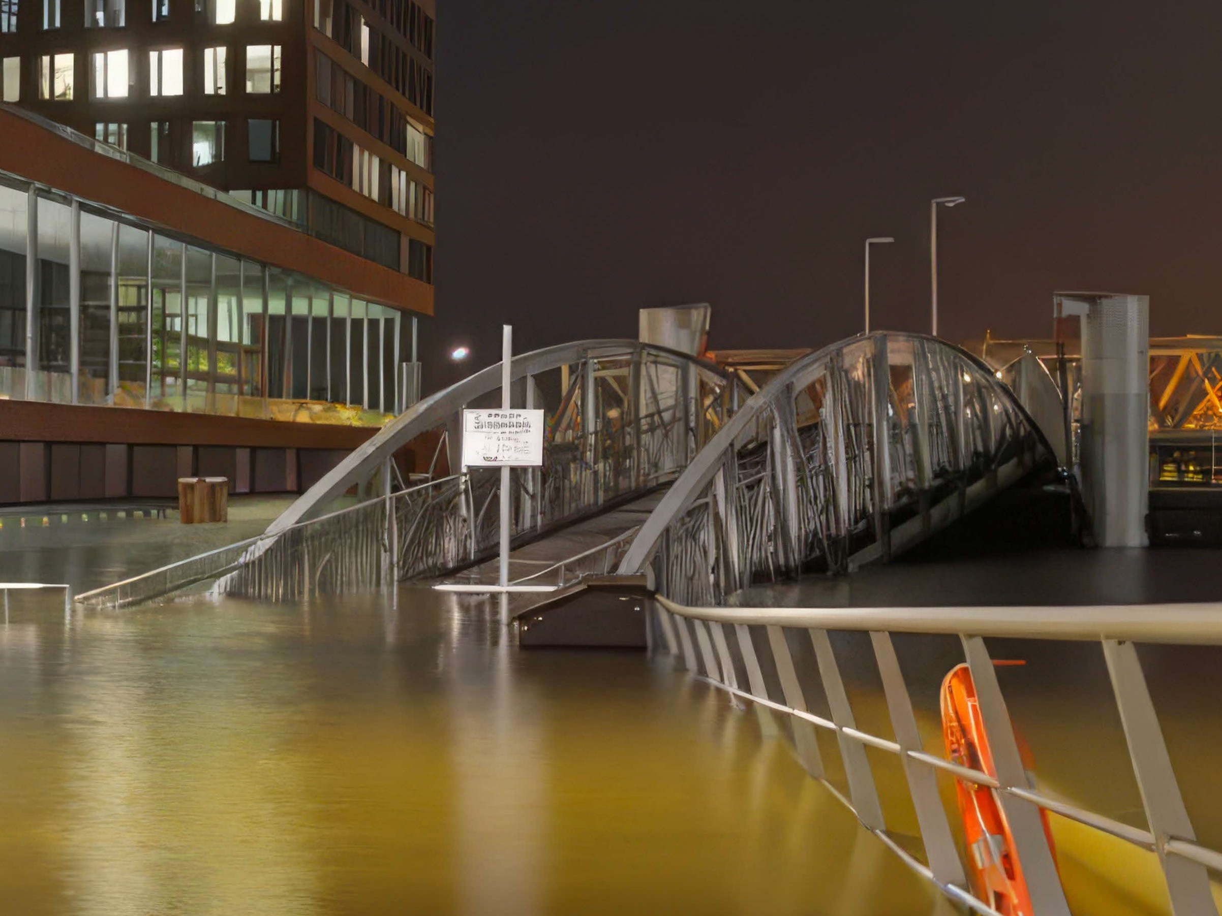
HafenCity during high tides |
Tidal gates to complete the line of defence
Canals help to drain seawater into the sea, but the opposite can also happen. As sea levels rise, seawater can flow inland through the canals. To complete the continuous line of defence, tidal gates are needed at the outlets of these canals. These will close during high tides and storm surge to keep seawater out. On normal days, the tidal gates will remain open to let stormwater flow to the sea. The exact number and location of the tidal gates will be studied later.
Working hand in hand with nature groups
We have consulted nature groups on the location of the tidal gates in Changi. They highlighted the potential impact of building multiple tidal gates on intertidal habitats at Changi Creek, and the need to maintain ecological connectivity and manage water siltation.
After careful consideration, the recommended concept is to place the tidal gate near Telok Paku Road, downstream of Changi Creek. This will maintain some separation from the mangroves and reduce the environmental impact. It also means we need fewer tidal gates within the mangrove habitat along the shoreline.
The location of the tidal gates will be further studied in the design phase and subject to environmental impact assessment to minimise impact on the environment.
The Greater Southern Waterfront (GSW) stretches from Pasir Panjang Terminal to Marina East, featuring popular destinations like VivoCity, Marina Bay Cruise Centre Singapore, and Labrador Nature Reserve.
A major transformation awaits when the City Terminals move to Tuas in 2027, freeing up about 1,000 hectares of prime waterfront land. This presents an exciting opportunity to repurpose the spaces for live, work and play while integrating essential coastal protection measures.
Along the southern coast under the Greater Sentosa Masterplan, there are initiatives to create a seamless waterfront promenade with opportunities for the connectivity to be extended to Sentosa and Pulau Brani, envisioned to host world-class attractions, enhanced beach experiences, and expanded nature and heritage trails.
A tale of two choices: What stakeholders say about the options for GSW
Two coastal protection schemes have been considered for GSW. One is the centralised scheme, where coastal barriers are built at the eastern and western ends of Sentosa and Brani to protect the coastline behind them. The alternative is a decentralised scheme, which would require walls hugging the entire shoreline of GSW with multiple tidal gates and pumping stations at the respective drain outlets.
| Decentralised coastal protection scheme | Centralised coastal protection scheme |
|---|---|
| ✓ Provides greater flexibility for incremental build of coastal protection measures | ✓ Protects a larger area, including Pulau Brani and northern Sentosa |
| ✕ Blocks sea view | ✓ Offers connectivity opportunities between mainland and the islands |
| ✕ Requires more land space to accommodate multiple tidal gates | ✓ Maintains a seamless waterfront experience with less disruption to businesses, residents, and waterfront users |
| ✕ Potential impact on existing biodiversity (e.g. intertidal areas) | ✕ Potential impact on marine vessel movement and biodiversity |
Pros and cons of the coastal protection schemes discussed at Our Coastal Conversation
We recommend adopting the centralised scheme for GSW consisting of coastal barriers.
Operating the movable coastal barriers
The current concept is for the coastal barriers to be open by default. The barriers will be closed only during storm surge events to prevent coastal flooding.
Keeping the barriers open offers marine vessels unimpeded movement along the Southern waterways. It also reduces impact on water quality and biodiversity. There are trade-offs in every decision. We will need to weigh the pros and cons to arrive at an outcome that delivers the most benefits to Singapore.
Enhancing connectivity via the Eastern Barrier
The Eastern Barrier will connect mainland Singapore to Pulau Brani and Sentosa. There are also opportunities to integrate the barrier with future development plans for Sentosa and Pulau Brani, to improve the connectivity of the area. Details will be worked out in the design phase.
Considerations for the Western Barrier
The exact location of the Western Barrier will be studied further during the design phase. Multiple factors will be considered. For example, building the barrier at the narrowest parts of channels could reduce construction costs and time. However, this might disrupt existing natural habitats at the barrier landing points and areas enclosed by the barrier.
Therefore, environmental impact assessments will be conducted during the design work to inform these decisions. We will also engage stakeholders to understand the potential impacts and explore solutions that balance technical feasibility, cost, and impact on biodiversity.
Upgrading Marina Barrage for future sea levels
Improvements to existing infrastructure may also be needed to address rising sea levels. The Marina Barrage, which was completed in 2008, will have to be upgraded to maintain the continuous line of defence. We may need to close the gap between the crest gates and the bridge with beams and seals.
The ‘Long Island’ project is an integrated solution that serves multiple national needs. Around 800 hectares of land will be reclaimed to form a continuous line of defence against rising sea levels. Two barrages and pumping stations will be built on the reclaimed land for flood management, to keep seawater from flowing inland during high tides.
Technical studies are currently underway for the ‘Long Island’ reclamation project.
Discover more about the Long Island Plan on the Urban Redevelopment Authority website.
Changi Region is envisaged as Singapore’s business gateway to the world. It will host industries that maximise synergies with Changi Airport as well as key economics nodes such as Changi Aviation Park, Changi Business Park and Changi East Urban District.
There is also potential to enhance Changi Point as a recreational node along the Greater Rustic Coast while celebrating its heritage through sensitive adaptive reuse of key buildings as well as introducing new recreational, hospitality and lifestyle experiences to the area.
Seeing the coast from many views
The coastal protection measures along Changi Beach Park could either be built at the shoreline or set back further inland. While the shoreline option allows us to protect more land from flooding, access to the beach will be affected. During our public engagement, stakeholders agreed that setback solutions provide larger intertidal areas. This enables biodiversity to thrive and nature-lovers to enjoy the area without disruption. Stakeholders also suggested ideas on how the space could be used, including building a boardwalk, as well as facilities for birdwatching, fishing and camping.
Conserving the Changi coast: Adaptable solutions for future needs
The recommended coastal protection for Changi combines raised structures with natural high ground and future developments to create a continuous line of defence. In some segments, raised structures are positioned away from the shoreline to preserve the beach and minimise impact on the existing intertidal habitats.
Key benefits of raised structures
✓ An adaptable design that allows height adjustments to be made in tandem with rate of sea level rise
✓ Opportunities for multifunctional use
✓ Less construction and maintenance complexity
While the beach will remain accessible, there will be times during high tides and storm surges when it may be transiently flooded. People are advised to avoid the beach until the extreme coastal surge events subside. Safety measures will be put in place to guide visitors away from affected areas during these times. This reflects a key principle of coastal protection: it's not just about preventing floods, but also learning to live with them.
Going with the flow
Germany's HafenCity is an example of how communities can adapt to life with water. This city of 8,000 residents has built their buildings on artificial hills 8 metres above sea level. Meanwhile, residents visit the low-lying waterfront promenades during low tides to catch the scenic views.
|
HafenCity under normal conditions |
HafenCity during high tides |
Tidal gates to complete the line of defence
Canals help to drain seawater into the sea, but the opposite can also happen. As sea levels rise, seawater can flow inland through the canals. To complete the continuous line of defence, tidal gates are needed at the outlets of these canals. These will close during high tides and storm surge to keep seawater out. On normal days, the tidal gates will remain open to let stormwater flow to the sea. The exact number and location of the tidal gates will be studied later.
Working hand in hand with nature groups
We have consulted nature groups on the location of the tidal gates in Changi. They highlighted the potential impact of building multiple tidal gates on intertidal habitats at Changi Creek, and the need to maintain ecological connectivity and manage water siltation.
After careful consideration, the recommended concept is to place the tidal gate near Telok Paku Road, downstream of Changi Creek. This will maintain some separation from the mangroves and reduce the environmental impact. It also means we need fewer tidal gates within the mangrove habitat along the shoreline.
The location of the tidal gates will be further studied in the design phase and subject to environmental impact assessment to minimise impact on the environment.
With the conclusion of the Site-Specific Study, we will be embarking on the preliminary and detailed design, followed by construction of the coastal protection measures in the 2030s.